Coastal Ecosystem Monitoring (CEM_CV)

Country/Region
Cabo Verde
Project duration
July 2019 to July 2021
project summary
The Coastal Ecosystem Monitoring in Cabo Verde (CEM_CV) project will develop standards for a coastal monitoring program in a region where no systematic ecosystem observations exist so far in order to improve local knowledge about the marine coastal environment and the biodiversity around Cabo Verde to support evidence based decision-making processes. The requirements of this observation program will be co-designed with local stakeholders and local and international scientists and validated by pilot field surveys. These surveys engage with different communities and will use state-of-the art observation technologies including ship-, glider- and drone-based methods and low-cost, cellphone based sensor systems.
The long-standing bilateral cooperation between German and Cabo Verdean partner institutions has already established substantial infrastructure in Cabo Verde such as the Ocean Science Centre Mindelo (OSCM) or the outfitting of a local research vessel with modern oceanographic equipment to conduct open-ocean research in the region. CEM_CV puts emphasis on communicating obtained scientific results in an appropriate language back to local stakeholders and decision and policymakers to support knowledge-based sustainable development of the coastal zone and the marine environment.
Through this approach CEM_CV aims to set the cornerstone for a coastal ecosystem monitoring program that can be operated by local investigators and technicians on their own and can be expanded to other regions in Cabo Verde and beyond in a sustained way.
Key Targets
Develop standards for a coastal monitoring program to improve local knowledge about the marine coastal environment and the biodiversity around Cabo Verde
Developing a blueprint for a coastal ecosystem monitoring program that suits the needs of local stakeholders and provides policy-makers with valuable input for decision-making processes based on scientific evidence
Developing human capacities at stakeholder level, strengthening university programs and furthering institutional capacities while improving data accessibility in order to enable Cabo Verde to transform the blueprint into a sustained long-term program
Developing a training scheme for coastal communities and stakeholders to improve observation capacity as well as the use of data and data projects for the benefit of different sectors
Creating user-specific outputs include data fact sheets on the observations and product summaries on possible use of the observations for decision makers and end users in consultation with these user groups
Developing a strategy for continuation of the monitoring after the project’s lifetime together with local policy-makers and stakeholder
project news
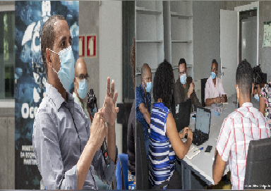
Kick-Off Workshop: Coastal Ecosystem Monitoring
During the hybrid Kick-Off meeting on 18 and 19 November 2020, the “Coastal Ecosystem…
MeerWissen Webinar: Coastal ecosystem monitoring in Cabo Verde
The Coastal Ecosystem Monitoring in Cabo Verde (CEM_CV) project was introduced on December…
Cabo Verde joins Fisheries Transparency Initiative
The MeerWissen project “Coastal Ecosystem Monitoring in Cabo Verde” (CEM_CV) used the Cabo…
areas of work
Study design and analysis
- Technical Training Workshop on the use of hydroacoustic technologies for ecosystem observations such as obtained from gliders and shipborne acoustics
- Pilot study design workshop brings together international experts in ecosystem monitoring programs, local scientists, stakeholders, authorities (e.g., coast guard) and policy-makers to co-design the pilot survey
- Workshop on the collection of fisheries data and vulnerable species information comprising both representatives of the local fishing communities and the management to satisfy needs of both sides and also international experts
- Data analysis workshop to analyse obtained data and prepare them for dissemination. This will include spatial analysis and overlap generation to indicate hotspots of risk of conflict of interest and for nature conservation
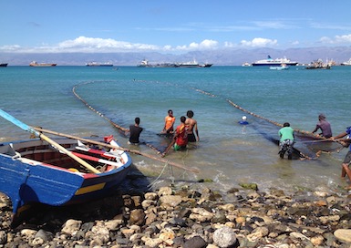
User assessment of coastal areas for fisheries and ecosystem data
- Fisheries mapping to improve knowledge on the amount of fish caught using a self-reporting system with mobile devices for local fishermen
- Mapping of other uses such as housing, farming, roads and traffic, energy production and recreation to achieve overlay plots as a starting point to define hotspots and management needs
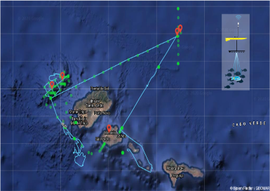
Pilot survey and field work
- Pilot study containing a dedicated ship survey at sites in Cabo Verde that need to be defined during the co-design workshop
- Tagging studies to reveal habitat use of large vertebrates in the area chosen
- Mapping of shoreline and coastal habitats to identify shoreline habitats along the selected coast in order to fully comprehend interference with land based activities such as coastal construction, aquaculture and tourism
Outreach and dissemination
- A web-platform will present the project as a whole. More specific webpages will be developed focusing on processed data and data products and will also serve as a communication platform for local stakeholders and policy-makers
- National level workshops, fairs and exhibitions present information material, leaflets, posters or oral presentations
- Continual concept development via regular Management Committee meetings and hosted events
- Side-events and presentations at international science conferences
- Scientific publications will be prepared at the end of the project
partners
IMar - Instituto do Mar I.P.
University of Cabo Verde (UniCV)
Thünen Institute for Sea Fisheries (TI-SF)
University of Kiel (CAU)
GEOMAR Helmholtz Centre for Ocean Research Kiel