Taking the Pulse of The Ocean (PULSE)

Country/Region
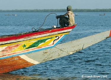
Senegal, coast close to Dakar
Project duration
July 2020 to July 2022
project summary
We want to increase the ability to access user-friendly, cost-efficient instrumentation and data of the coastal area; we want to close a loop from data to knowledge to action and back to data. By using cost-efficient devices measuring temperature, salinity and chlorophyll as proxies for probability of fish occurrence and establishing a tested process sequences we want to engage scientist, local authorities and beneficiaries in data sharing via public and easily accessible tools.
We want to establish methods for the use of cost-efficient sensors adapted to the needs of the coastal area of Senegal close to Dakar in the South Senegalese Upwelling system, by establishing workflows from regular deployment of instrumentation to data gaining and publishing, e.g. via mobile App as a tool.
The beneficiaries of this project will be coastal inhabitants, especially Senegalese fishing communities, local politicians and education hubs as universities and schools, which will be able to access and use the data via smartphone devices.
As an expected result, a tailored workflow will allow the sustainable data acquisition in the appointed Senegalese coastal area via App. This concept can be adapted to other coastal regions e.g. the Gulf of Guinea.
Key Targets
Finding a suitable and sustainable solution of retrieving ocean and coastal data for decision making processes
Making local data in the region accessible and useable
Disseminating the idea of a beneficial and participatory data gathering
Managing and publishing ocean data collection concepts for different user groups by using modern technology such as mobile apps
areas of work
Usage and maintenance system for ocean sensors
- Implementation of the usage, data validation and open-access publishing of ocean sensors
- Engaging local capacities, from fishermen to scientists, in deploying, maintaining and data collection
- Ensuring efficient data validation and calibration of devices through scientists to ensure the quality control of the uploaded data
Smartphone mobile application for locally gathered data
- Provide different stakeholder groups (academia, government, decision makers and local communities) with accessible and pre-processed data through a mobile application
- Inclusive participatory process to find best-fitted solutions for this specific region
Educational units and teaching & training modules for sensor handling
- Conduct a core training on the workflow and the calibration of sensors and the validation of data at the reference site in Germany
- Train scientists (junior and senior) in establishing teaching and training models independently
Sustainability of project outcomes
- Creation of a mostly pictographic manual/ hand book for handling and maintenance of cost-efficient sensors available for all sectors
- Manual for handling the oceanographic data mobile app to ensure accessibility for all groups and enable quality control
Partners
Laboratory of Atmospheric Physics and Ocean Siméon Fongang (LPAOSF)
Biologische Anstalt Helgoland (BAH)
Alfred-Wegener-Institut Helmholtz-Zentrum für Polar- und Meeresforschung (AWI)